Groundwater of the Geneva basin under scrutiny from hydrogeologist

© 2011 creative commons Wikipédia
Could our drinking water resources be at risk from drought, among other things? The canton of Vaud has commissioned an EPFL laboratory to draw up a geological map of the conservation and the water resources.
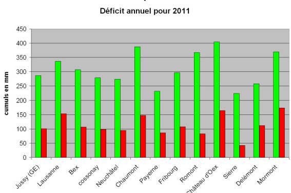
A snowy autumn, undoubtedly, but a dry winter, a spring with no rainfall and the early snow thaw have had a major impact on the groundwater and may do, in turn, on our drinking water supply. According to MétéoSuisse, the rainfall shortage is the second most severe since records began in 1864.Rainfall levels reported in 2011 against the 1961-1990 norm (in mm): in green what should have fallen; in red what actually fell.
Professor Aurèle Parriaux of the Laboratory of Engineering and Environmental Geology (GEOLEP) is not unduly worried for communities with a pumping-system to the lake: “Lake Geneva is the second largest drinking water reservoir in Europe and with Lake Baikal we have enough resources; this is a costly additional solution though because the water has to be drawn and filtered before it can be distributed and consumed”. For those that rely on groundwater alone, it will certainly be a trickier matter. The Professor advises various towns in the region on the optimal management of their groundwater reserves. “In Switzerland we have been using the groundwater table in a renewable way over the last few decades. The hollow is created, a specific proportion of the water is taken and then the sheets are left to refill in periods of low consumption”.
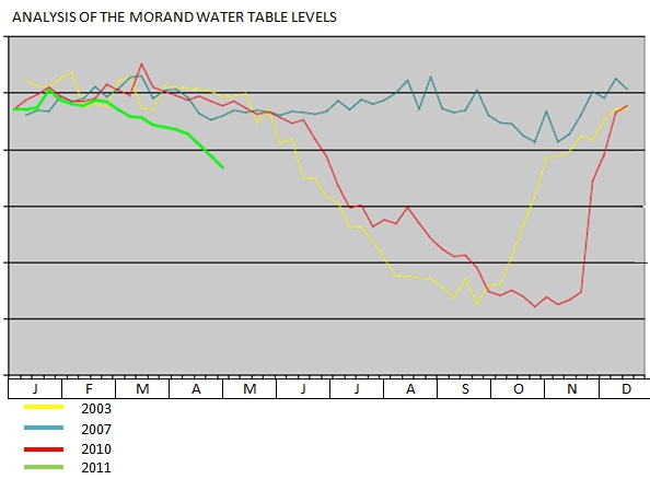
The “Morand” groundwater
The Geneva basin contains around 20 large groundwater sheets of a few square kilometers that each supply between 10,000 and 20,000 inhabitants. These are solid and stable sheets generally situated around 10 meters deep that are fairly impervious to rainfall and drought. The Morand groundwater sheet is one of these. The spring was bought in the 1930s by the town of Morges. It’s situated in the Morges wood, at the foot of Montricher. For over 80 years, it has been supplying all the households in the town as well as the neighboring villages at a rate of nearly 7000 liters per minute. Even at the beginning of May 2011, its level is already unusually low. It corresponds to the data recorded in June 2003, the heat-wave year, and June 2010, which was particularly dry. Professor Parriaux’s expertise was sought: ‘This drying-up process is abnormal; it’s starting two months early. There is a risk that very low levels will be reached this summer". In very critical cases, drastic solutions may have to be considered such as the emergency drilling of new wells installed in the parts of the groundwater sheet that still show a large reserve.”
In green, curve of the Morand groundwater in 2011
This would not be the first time Aurèle Parriaux has had to present this solution. Around twenty years ago, the Joux Valley had to confront two ecological disasters in quick succession. The source in Le Brassus was contaminated by some slurry just a few days before a rail accident at the edge of Lake Brenet resulted in the drinking water well being taken out of service because of oil seepage into the ground. Emergency wells made it possible to supply drinking water to the local inhabitants.
Natural reservoirs
The water resources must be identified and preserved: “These natural reservoirs have very different inertias. The deep groundwater sheets such as those in the Aubonne delta will not be too badly affected because they are extremely thick. However, I know that some sheets at the foot of the Jura are already in difficulty”, the Professor explains. Empty groundwater sheets also cause problems for rivers because they serve as their supply when there is no rain. The water levels of the Venoge, for example, are extremely low and some sections have dried up. Morges is drawing some water from its Morand sheet and diverting it into the river to sustain the low water levels on the Veyron River. It’s a matter of preserving the ecosystem. With conservation in mind, the canton of Vaud commissioned Professor Parriaux’s team to draw up a hydrogeological map of its land. “We used a consistent mathematical model that transposes geological knowledge into water-resource parameters such as the permeability or thickness of the groundwater sheets. That enables us to map out new groundwater sheets. They form in sites where the geological material is permeable, such as the gravelly alluvia deposited after the ice age or in the chalky rocks.” There is an increasing demand for water and meeting this will require exploring and drilling much deeper this time. At the foot of the Jura, a 200-meter well has just been drilled. “This is undoubtedly a critical year; showers and storms will have no effect on the groundwater sheets because the water will stay on the surface. For this to improve, we can wish for one thing only: a rotten summer!”