Mapping urban underground potential

Michael Doyle’s dissertation is the fourth to come out of Deep City. © Alain Herzog / EPFL 2017
An EPFL researcher has taken a methodology designed to improve underground urban planning around the world one step further. The study, which combines geology and economics, encourages a more rational approach to underground development while safeguarding natural resources.
Cities tend to sprawl outwards or expand upwards. Their underground potential is often overlooked or underestimated in master zoning plans. In fact, urban planners may only look below the surface when a subway or underground walkway is being built. This shortsightedness can have dire results, such as underground flooding, polluted drinking water and conflicting uses.
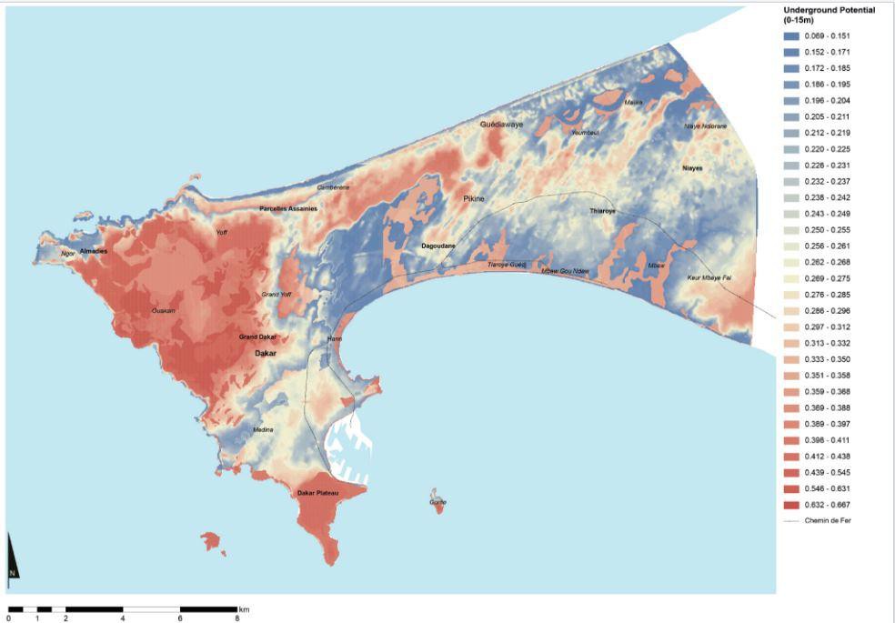
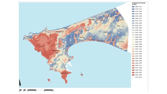
Michael Doyle, a student in the Laboratory of Environmental and Urban Economics (LEURE), which is headed by Philippe Thalmann, chose this topic for his dissertation. Over the course of four years, he mapped out the ground below three cities with very different political, economic and geological characteristics: San Antonio (Texas), Hong Kong (China) and Dakar (Senegal). He applied the Deep City methodology, which was developed at EPFL by geologist and Honorary Professor Aurèle Parriaux. The Deep City approach is to simplify complex geological maps so that cities can use them to plan below-ground development while protecting the natural resources found there.
Simplified maps
Doyle's research built on the Deep City methodology. He spent time in the three cities and developed a coefficient system for each underground resource: groundwater, building space, geothermal energy and geomaterials. His aim was to provide decision-makers with a useful metric to apply in their underground development planning. The simplified maps produced from these coefficients have proven to be relevant in all three cities, irrespective of their economic and political landscape.
These maps will also help urban planners develop a more rational approach to underground planning while taking into account below-ground resources: a subway could be built alongside a geothermal system; the risk of groundwater seepage or contamination when building a tunnel could be better assessed; and excavated materials could be usefully recycled. “You don’t get a second chance with below-ground construction,” said Parriaux, who authored the first version of the Deep City method. “It's not like a building, which you can always knock down or renovate. This makes planning essential.”
Montreal: an economic success
In addition to his geological research in San Antonio, Hong Kong and Dakar, Doyle also analyzed the relationship between Montreal’s underground and its downtown. He wanted to see just how much the below-ground structures contributed to the economic success of the city’s commercial spaces. Doyle’s research showed that Montreal could serve as a useful model for other cities: its underground passages see a relatively constant level of traffic throughout the year. “The walkways don't compete with the surface streets, there’s no conflict between the two spaces,” said Doyle, referring to another study on Montreal.
Doyle’s work on that city consisted in mapping indoor and outdoor commercial spaces and building a spatial econometric model of commercial rents. His map identifies the accessibility criteria and locational advantages that contribute to the economic success of a city with significant underground space. Doyle’s work provides useful insight into the important interaction between above- and below- ground commercial spaces in Montreal.
Doyle’s dissertation is the fourth to come out of Deep City, an interdisciplinary initiative that was launched in 2005 by the Swiss National Science Foundation Project PNR 54. The researcher looks forward to presenting his work to the City of Lausanne, which has expressed an interest in it.
Reference:
Michael Robert Doyle, Potentialities of the Urban Volume: Mapping underground resource potential and deciphering spatial economies and configurations of multi-level urban spaces, Deep City Project, Laboratory of Environmental and Urban Economics (LEURE), advisors Philippe Thalmann, Aurèle Parriaux, EPFL Dissertation 7328, December 2016.

Images to download