Geospatial data helps to better understand Parkinson's disease

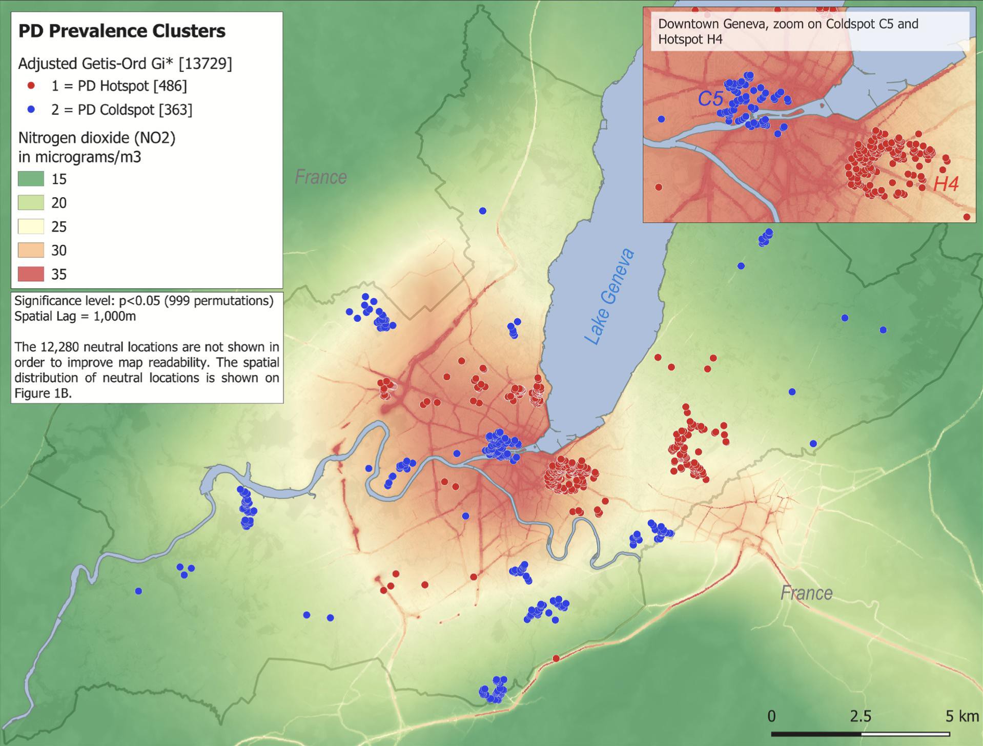
Distribution of Parkinson's disease hotspots and coldspots in the canton of Geneva, associated with air pollution. © LASIG
In a new paper, a team of EPFL spatial-analysis experts and neurologists from Geneva University Hospital (HUG) show that the probability of developing Parkinson's disease is higher in the canton of Geneva's urban centers than in its rural areas. This constitutes an important contribution to the study of the causes of this neurodegenerative disease, which are still poorly understood.
Parkinson's disease, which progressively destroys certain types of brain neurons, affects some 15,000 people in Switzerland. It’s the second-most common neurodegenerative disease after Alzheimer's. Its frequency increases with age and it tends to occur more frequently in men. Although the cause is still largely unknown, scientists agree that in most cases a combination of hereditary and environmental factors play a role.
By studying the geographic distribution of Parkinson's patients in a given area, scientists can identify clusters of higher or lower prevalence and, based on this, extrapolate potential environmental risk factors. In 2018, HUG neurologists Pierre Burkhard and Vanessa Fleury carried out Switzerland’s first assessment of the incidence of Parkinson's disease, in the canton of Geneva. They used their findings to compile an anonymized database of Parkinson's patients. “Prof. Burkhard had noticed that several of his patients lived close together, and thought there might be localized clusters of the disease in the canton. Then I worked with him to find a way to scientifically substantiate his hypothesis,” says Fleury.
Are there places where Parkinson's disease is more prevalent than elsewhere?
Fleury met with Dr. Stéphane Joost and his student Rebecca Himsl, after being put in touch by the Population Epidemiology Unit at HUG and Prof. Idris Guessous – a long-time research partner of EPFL's Geographic Information Systems Laboratory (LASIG). Himsl subsequently selected this topic for her Master's project. Bringing clinicians and spatial-analysis experts together on a cross-disciplinary team proved to be highly effective. “We looked at the situation from an epidemiological point of view and asked: Are there places where Parkinson's disease is more prevalent than elsewhere?” says Himsl, now a flood-risk analyst for a Canadian company. The results of the study were published in Parkinsonism & Related Disorders on 1 February.
New perspectives
The study's findings are enlightening, above all in terms of the methodology used, which puts forth a new approach to environmental epidemiology research. The team linked environmental and epidemiological data regarding the age, gender and address of the canton's 1,115 Parkinson's disease patients, and drew up detailed maps of case distribution based on specific environmental exposure factors. To create a control group, they incorporated data on 12,614 Geneva residents collected by the Population Epidemiology Unit's Health Bus between 1995 and 2014. This approach based on individual cases differs from the more conventional method of aggregating data, which can be less accurate for detecting highly localized areas of disease prevalence.

“A very complex set of causes”
“We geolocated patient groups taking into account known confounding factors such as age and gender. This allowed us to pinpoint local hotspots with a higher prevalence of Parkinson's disease. Such spatial dependence concerns a small percentage of patients (6%), but remains statistically significant even after all factors that could contribute to Parkinson's disease have been eliminated,” Himsl explains. Her findings, generated in part by a probability model, also make it possible to identify “coldspots” – areas where fewer people than average are affected by Parkinson's disease.
It's all part of a very complex set of causes. Sometimes, however, we can identify a dominant factor
The study shows that most Parkinson's hotspots are located close to downtown Geneva, in contrast to coldspots, which are situated on the outskirts. “There is a significant positive correlation between these hotspots and the degree of air pollution, which leads us to suspect that there is a link between Parkinson's and atmospheric pollution. Our study highlights two key facts: the multifactorial nature of Parkinson's disease, and the importance of improving air quality to prevent the disease,” explains Fleury. Joost adds: “It's all part of a very complex set of causes. Sometimes, however, we can identify a dominant factor, as we did here, which is very likely air pollution.”
Matching results – with two exceptions
When Joost picked up Himsl’s work after she graduated, he incorporated data recently made available by the Greater Geneva agglomeration concerning concentrations of nitrogen dioxide and suspended particulate matter. He then superimposed these data on Himsl’s maps and saw that they matched up across all the hotspots – except for the Eaux-Vives district near the city center, where air quality seems to be better, and the Les Délices coldspot, which shows high levels of nitrogen dioxide. “We will now try to identify one or more possible explanatory factors and publish them in a new paper,” says Joost, who already posits that a confluence of positive factors close to home may reduce the risk of developing the disease.
“Thanks to the areas of prevalence that the study identified, it could be of use to healthcare providers,” says Joost. “We have shown that there is a greater likelihood of developing Parkinson's disease in certain types of neighborhoods, which could lead policymakers to introduce measures to protect residents or improve facilities in these communities. Our findings will also help the HUG neurologists we worked with, who can now focus on looking for other factors that explain the onset of this disease.”
This study was supported by donations from Parkinson’s disease patients and by an unrestricted grant from Novartis, Lundbeck and Boehringer Ingelheim. The “Bus Sant ́e” study was funded by the Geneva University Hospitals through the General Directorate of Health (Canton of Geneva, Switzerland).
"Geospatial analysis of individual-based Parkinson's disease data supports a link with air pollution: A case-control study", Vanessa Fleury, Rebecca Himsl, Stéphane Joost (These authors have equally contributed to the manuscript.), Nicolas Nicastro, Matthieu Bereau, Idris Guessous, Pierre R. Burkhard. Publié 1 February 2021 in Parkinsonism & Related Disorders
https://www.prd-journal.com/article/S1353-8020(21)00002-X/fulltext
Images to download